Pinhoti Trail: Day 3 - By Eric
Pinhoti Trail Adventure Run Day 3
Waking up to the sound of rain at the America's Best Value Inn located in Heflin, Alabama might as well have been foreshadowing of the events that would soon unfold. It had rained most of the night and it continued steadily as we packed our last minute gear into each crew vehicle. We were fortunate enough to have a very short drive to the trail head at I-20, which meant that we were able to get a little extra sleep on this morning. That was welcome, as we had quite the contingent of people hanging out in our room the night prior while we watched 'Talladega Nights' and ate Mellow Mushroom Pizza. I was starting to run into sleep debt as I was now coming off of my third night of restless sleep not totaling more than a dozen hours since waking up Friday morning. For the record, it was now Monday, May 3rd.
In the first 37 hours since our start on Saturday morning we had covered 101 miles, marking my first 100 mile event completion. I was letting this accomplishment fuel some positive thinking as I sat in the back of Josh's (Kennedy) Xterra and listened to Matthew (Kennedy) talk to himself about the hotel not being much of a value without a pool or breakfast. He did have a point, but it was the best that Heflin had to offer.
In a small convoy we drove to the trailhead and after putting on our rain gear, Rob (Youngren) and I along with pacers David (Riddle) and Blake (Thompson) took to the first trail section. The sections of trail between road crossings where we would meet our crew were all relatively short during the morning and at less than 3 miles, the first jaunt in the woods was no exception. I lead the way with Rob and gang following closely. I realized very quickly that unlike the first two days where we were able to maintain dry feet all day, that the low lying areas and water sheds of this day were going to be different. The continued rain had the streams full and within minutes my shoes were saturated with water. Normally this would have been fine, but with my now fully developed blisters on each forefoot, running with wet feet all day was just going to exacerbate the problem.
It was not long after this that I also came to the realization that I was holding up Rob with my slow pace and walking of the downhills. As with the end of day 2 I was able to climb fine, but the forefoot pressure felt on the downslopes was intense. After crossing a barren section where a tornado had rolled through in the recent past, we came to the road crossing where we met our crew. I used this opportunity to take two Tylenol in hopes of numbing the pain. It was a quick stop as we just had another 3 miles to go before the next stop.
The terrain changed when we crossed the road as it turned into a lush rain forest with green foliage and more water crossings. Rob was now setting the pace and despite David wanting to run behind me (to keep me with the group) I asked him to run ahead as I was hurting and I was starting to alternate running with walking which did not hurt nearly as bad. As we approached the 6 mile mark, we had a long downhill with a short powerline crossing that lead down to the crew vehicles. Kathy, Sarah and Blake were planning on heading back into Heflin to get breakfast sandwiches from Hardees and I was looking forward to some solid food as I was too nervous at the start of the day with the rain to eat. As we popped out of the woods, the rain began to subside so we could stand and eat with the gang without having to huddle up under the back hatch of the Xterra. The food really hit the spot and helped to calm my nerves.
I was ready to roll before the others were and I started to walk down the hill hoping to get back into the grove before the others caught up. I was doing my best to manage my pain but it was starting to exceed the threshold of what I could tolerate for any period of time. Within a few minutes we were together as a group and jogging along. We approached a section where there was a downhill that I could not attack with the same intensity as Rob was prepared for, and I stepped aside to let them run through. Of course not feeling as strong as Rob this early in the day was a little emotionally tough, but I tried to stay head strong. I kept up as well as I could for the next few miles but the constant flexing of my forefoot with every step was aggravating my blisters to the point where I knew that I needed to take immediate action. I decided on the approach to one of the hill climbs that I would sprint ahead and have Josh work on my feet in hopes that we could perform some miracles quickly and I would be able to minimize the impact on Rob.
So I locked in a very fast pace for the next mile, powering up the hills climbs and flying on the downhills, fighting through the pain of each foot fall. David caught up with me toward the latter half of the mile as we came to the road where Josh waited. I immediately grabbed the folding chair and sat down so he could inspect the problem. I had him focus on my right foot, which was much worse than the left, being a right side dominate runner. He drained the blister and did some other informal medical work as I bit down on my hat to avoid screaming out like a little girl. I had never experienced anything like this before in my limited distance ultra-running endeavors before. Josh did not seem to be in a hurry and I could tell that Rob was getting a little frustrated as we had a very long day ahead of us with the last 18 miles up and over Dugger Mountain. He bandaged me up and I put my shoes back on after about 10 minutes.
I gave it my very best effort to keep up the pace but before too long it was David and I walking together as Rob and Blake slowly pulled away. This would be the last time I would see Rob all day. David seemed to know precisely what I needed; to walk in silence. He knew that I was agonizing in pain and that I was going on pure guts at that point as I refused to give up. He asked once about the pain and I said that it was in every step that I took, but that walking was not as painful. I thanked him for sticking with me and we talked for a little while. I really appreciated his company as without him I probably would have sat down on the side of the trail and quit all together.
After quite some time, we popped out at the trail head. Josh, Blake, Kathy and Sarah were all there. Josh immediately advised David to go out and get Rob; he had left just minutes prior.
Rob and I had this painful discussion a week prior where we talked about the inevitable; what would we do if either runner started to fall back. We decided that our immediate protocol would be to slow down for a few miles and see if the other would recover. After that, it was to move on and separate, hoping that by the end of the day, the other runner would make up the distance so we could start together again on the following day.
So as I got to the crew vehicle I immediately went for my phone. I needed some advice from my wife Laura, who I knew would speak from her heart. This was in no way a sign of weakness or of a meltdown; the others around me could see what was happening and I needed an unbiased opinion from Laura. I have never called her on anything like this before, but at this critical point in the adventure I thought it was very appropriate. I explained my current situation and the pain that I was under. I shared with her the facts and what I was feeling. She said that I could quit for the day and just join back in later. I explained to her that if I quit now, the adventure was over for me. It was an end-to-end thru-hike not a jump in the car anytime it hurts run. To be honest I am not sure how the rest of the conversation went, but she instilled the notion in my head that I would deeply regret it later if I stopped now.
So on that note, I refilled my bottles and with Blake in-tow, I headed out on the next section with a refusal to quit. I just needed a reality check and someone from home to talk to me.
The next 4 and a half miles were probably the best 4 and a half miles of the entire week in regard to scenery. The course was rolling terrain with easy footing and with the best stream and river crossings I have ever seen. Several times we were nearly waist deep and it felt so good on my feet and aching joints. Blake made a few attempts at small talk and tried to get me to run, but it wasn't working and I was honest with him that I appreciated his trials but I just needed the company to keep me moving. As we approached the far end, we came across Sarah and Kathy who were waiting for us.
This was the most pivotal point of the entire run for me. I was utterly convinced that my adventure was over. I had my mind made up. I sat down on the ground and took my shoes off. I was done.
It is hard to tell from these pictures, but the blister on the bottom of my right forefoot caused my gait to change which gave me a large blister on the back of my left heel.


Kathy then started a conversation with me that I will never forget. She said that she had talked to Dink (Taylor) and to (David) Horton. I am not sure who said what, but here are the phrases she told me...
"What did you expect?" (As in, did you think it was going to be easy?)
"It almost always never gets any worse" (As in, it has to get better)
I kept telling Kathy that I was thinking clearly and that I had been contemplating the decision to quit for the last four hours. I told her that I was completely fine with my choice. She responded with:
"Pull your head out of your ass and get going" (As in, harden the fuck up douche bag)
And with that, I changed my shoes and socks and got going. I will never forget her helping me to get my head on straight and suck it up.
So for the next 3 miles or so, I was paced my Sarah Bowden. Sarah had a much different approach to pacing than Blake or David. She refused to stay quiet or let me wallow in my own self-pity. She sang for awhile, talked about non-running things, asked me questions about my favorite color, etc. It was very entertaining and helped to keep my mind off of the pain. In no time at all, we had covered the section from FS 531 to FSR 500.
I was entertained mightily here by David Riddle sporting his McKay Hollow trucker cap which clearly did not fit his head. I thought it looked ridiculous which was probably the look he was going for to keep my spirits up. I took some time at this aid stop to sit down and rest. I stayed there for about 5 minutes in heat of the mid-day sun before getting my act together and preparing for the next section. Kathy offered to go with me but I was ready to tackle a few sections alone, so I set off sans pacer this time.
The next few sections walking alone were a combination of a pity-party along with some true soul searching. At times I would stop and lay on a bridge for a few minutes trying to get some time off my feet and at times I would attempt to shuffle briskly and make up the time I spent vertical on the bridge. Yet all in all, I was moving forward.
On each section, the crew would jump ahead and then hike back in to find me. Before Choccolocco Creek Lake, Blake hiked back in along with David and carried my into the crew spot. When we got there, Kathy and Sarah were lying out on the "beach" trying to catch some rays. Apparently the beer drinking had already started; I was jealous that I could not partake.
After Kathy put out my inflatable sleep pad, I proceeded to lie down and rest for a few more minutes. This excessive time at each stop was going to severely limit the distance that I would log for the day but at this point I was just thinking about making forward progress. Finally I decided it was time to move on and as I slammed my Boost and ate my string cheese, I decided that it was time for me to enlist the help of my new Black Diamond Spire Elliptical Trekking Poles. I picked these up a few weeks before the adventure, though I had not used them yet. They are the same model that Karl Meltzer uses.
As soon as I left the crew, I immediately encounter a section of trail that was totally under water. Wanting to keep my feet dry after they had been re-bandaged, I hiked upstream until I could find a place to cross. it took a considerable amount of time, but keeping my feet dry was the number one priority. The poles proved to be helpful right away as I used them to stabilize my jump across the stream and then hike up the hill.
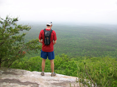
Toward the end of the section I came across yet another stream crossing. I decided this time to take off my shoes and socks and ford it barefoot. There was a shelter (Laurel?) on the other side with a picnic table. After crossing the water, I sat on the picnic table and sent out a Spot Messenger message and snapped this picture with my cell phone. This image truly captures how I was feeling; a picture says a 1000 words. I was dazed, spaced, out of it, etc. I just knew that I had to keep on pushing forward, one foot in front of the other. Toward the end, Kathy and Sarah had hiked back in to find me. Luckily I was not lying on a bridge when they got there, but actually moving fairly quickly with aid of my new best friends - my trekking poles.

Finally I could see that the crew was now expanded to include Eric Fritz. He was coming off of an impressive performance at Strolling Jim two days earlier where he shaved nearly an hour off of his best time. Eric would be crew for the next two days and then be running with us toward the end of the week.
I took the opportunity to adjust my poles by tightening the lower portion so I could place more weight on them pushing down without them collapsing. These two pictures show me with the screw driver then consuming more Boost and string cheese.


It was just a very short section from there and it was aided by my next newest best friend which was my iPod. I fiddled with it for a few minutes at the trail head as I walked away, trying to cue up something inspirational. I settled on a little Hannah Montana with "The Climb"; a song that I would continue to listen to for the next couple of hours.
At times I found myself just belting out the lyrics at the top of my lungs. I was catching my second wind and the pace was picking up. It may sound totally corny, but it was this damn song that lifted my spirts on this day. It turned out to be a good thing because at FSR 500, I would finally see crew chief Josh again and have to face the music on my plans for the next few days. I decided to do most of the talking, telling him how I felt and my plans to keep going. At this point I was still committed to trying to complete the entire 335 miles but had the 'B' goal of just making it the state line and completing the Alabama Pinhoti as a back up plan. He slapped me on the ass (figuratively) and told me to get going. David Riddle was leaving to head back to Huntsville so I took a quick moment to thank him for all he had done; it was well appreciated.
The next to last section was a short 1.9 mile stretch across some barren land that was wide open from a recent controlled burn. The ground still stunk of ash and cinder. I was jamming out to Miley and actually was in a running motion for 30 seconds at a time. This built until I was running for 1 minute, then 2 minutes in between breaks. I was starting to realize that I had just one more long stretch after this one and I would be done for the day, albeit 10-15 miles behind Rob. With about a half-mile to go and facing a slight climb, I cranked up the volume and ran it all the way in. It was a tremendous feeling to have Blake, Sarah, Eric and Kathy see me running when I got to the crew vehicle. I ran 1.9 miles in under 36 minutes; pretty blazing fast considering my previous mile splits were in the 20 minute range.
The last section was about 10km so I got together my pack and filled it with fluids and food. This could take 3 hours based on the terrain. I was ready and actually looking forward to going it alone, but Blake was elected to pace with me; probably to keep me going as we neared darkness. As with each aid stop from the rest of the day, I had asked for, and been denied to have a cigarette. I haven't had one in years, but I kept asking for them, seriously. I didn't really want one but I thought it was funny to be in the middle of something that required so much stamina and physical ability and want a smoke at the same time.
Blake and left out together, lightly jogging on the decent into the watershed. There were some great waterfalls as we hiked along a river for the next three miles. It was at the bottom of a deep valley and the notion of keeping dry feet was impossible. It was like "slush-mile" from Mckay Hollow (Monte Sano, Huntsville) times 10. The puddles were up to my mid shins and that was along the good parts of the trail. Blake lead the way and we actually made pretty good time.
With about 2 miles to go, we crossed an earthen dam and that is where I stated to hit the wall again. I had been going for 11+ hours and I was at a very low point, emotionally and physically. Blake started to pull ahead and I started to drop back, creating some seperation. I could tell that he was ready to be done. On the last summit, (which turned out to be the last summit before the last summit before the last summit) I had to stop and lean up against a tree. I was out of fluids and just ate the last of my food. I was ready just to lie down in the middle of the trail, as I had done earlier in the day. It was getting dark now in the woods so I knew that I had to pick it up a little to not have to use the head lamp, but my body was not responding.
The last 2 miles would take me about 45 minutes to cover.
Upon reaching the road, Blake told me that they were parked down at a trailhead, but that I had to hike down to get there. Here I am coming out of the woods and stopping my watch after a having "run" from 6:04:05 am for 13 hours, 6 minutes and 32 seconds until 7:10:37 pm, covering 35.1 miles at an average pace of 17:41 minute-miles. This put my three day total at 136.1 miles.

And then proceeding to collapse.

The completion of the first day of the Pinhoti Trail Adventure Run was made possible through extensive training. Day two of PTAR was all about pain management. Day three of PTAR was all about my pacers and the support of my crew. I am eternally grateful to you.
Stats
Start Time: 6:04:05
End Time: 19:10:37
Total Time Running: 13 hours 6 minutes 32 seconds
Total Distance: 35.1 miles
Elevation Change: 4,043' of elevation climb and 4,190' of elevation drop for 8,233' of elevation change.
PTAR Day 2 part 1 (GPS A): 3,164' of elevation climb and 3,010 of elevation drop
PTAR Day 2 part 1 (GPS B): 879' of elevation climb and 1,180' of elevation drop
Pinhoti Trail: Day 2 - by Eric
The completion of the first day of the Pinhoti Trail Adventure Run was made possible through extensive training. Day two of PTAR was all about pain management.
Sitting on the curb like school children waiting for the bus, Rob (Youngren) and I sat outside of the Super 8 in Sylacauga awaiting Josh’s (Kennedy) arrival. We were all packed up and ready to roll in the pre-dawn hours, ready to get back at it after a less than restful 6 hours of sleep. Finally Josh rolled in and we split our gear between his Xterra and Rob’s Mercedes, which would arrive later in the day when Kathy (Youngren), Blake (Thompson) and Sarah (Bowden) would assume the role of the second crew.
After an endless drive back to Porter’s Gap, we began to gear up for the first section of the run. At less than three miles to the first aid point, I grabbed just a hand bottle and shoved an oatmeal creme pie down as pre-run fuel. I dawned the rest of my running gear, including my inov-8 roclite 305’s and two Pro-Tec Athletics Patellar Tendon Straps to ease the pain of my runner’s knee.
The first 15 miles of running on this day is the same as the first half of the Mount Cheaha 50km that I had run just two months prior. Then the following 12 miles to Mount Cheaha State Park continued to climb to the top of Alabama near 2.400' of elevation. The day after the 50km in February, Eric Fritz and I had run the 12 mile section, so I was fully aware of the difficulty that this day would present.
As hastily as I had packed my gear, I realized within the first few minutes of running that I had forgotten to take any Tylenol. Luckily Rob had some packed with him so I took two right away. Not a good sign of things to come. We continued to run a decent pace through the first 2.7 miles where we reached Skyline Drive and walked down the gravel road across the river and rail road tracks where we met up with Josh and our good friend and day 2 pacer John Nevels.

From there, we had about a 7 mile section to Clairmont Gap where we would see Josh again. This section of trail was fairly uneventful and slow. John brought us up to speed on what was going on in the world of running with Chris Solinky's 10km record and the fast times at Miwok 100km. Being on the trail all day and preparing for the following day all night leave little time to catch up on newsworthy events that we would otherwise see on Facebook or Twitter.
Here we are coming out of the woods at Clairmont Gap in a photo taken by Josh.

Leaving Clairmont Gap, we had a 6 mile section to Adams Gap in which we would parallel the Talledega Scenic Highway, which is actually no more than an impassable jeep road. We were still just on hand bottles and wouldn't need the packs until later in the day. The trail immediately climbs up a steep hill that had us walking, just as I had done in the 50km race. After that, the 'Rock Garden' and slope of the trail from right to left meant much, much more walking. Honestly we were never really able to string together much of a running rhythm through the following miles based on the terrain. My knees where bothering me and I was ready for some more pain relief so when we rolled into Adams Gap at mile 15, I was ready to sit down. When I say sit down, I actually mean lay down. After I assembled my pack and slammed a Boost, I laid down on the pavement of Adams Gap Road and took off my shoes. I was beginning to get hot spots on the middle of my forefoot of each foot and I sensed that blisters would soon form under my callouses. Here we are seen just coming into Adams Gap at the Silent Trail crossing.

If we were wearing our 'suck-o-meter' shirts, the needle would be pegged on 'sucks-worse' during the next few hours until we made it to the State Park. The climb up Stairway to Heaven was just as I remembered it; nothing short of a bitch - a winding trail that switch-backed up 900' over 4 miles crossing large rocks covered in moss that didn't even closely resemble a trail. We hiked our way up to the 2000' mark where there was the first decent overlook of the day. We all sat down and when I say sat down, I really mean collapsed. I think that we were all pretty low on fuel, having not consumed enough today compared to the energy required to make this climb. I don't remember taking or having this picture taken, but it sums up how I was feeling at the 20 mile mark.

Continuing on along after a 5 minute rest where we re-fueled with string cheese and Boost, we climbed another 200' before reaching the top of the ridge line. We would remain along the ridge for another few miles actually making pretty good time. We still had not seen a single person along the trail which was very surprising given that it was a Sunday. The winds atop the ridge seemed to cut down on the humidity. The forecast had called for rain for two consecutive days now but we had not seen a single drop of rain.
We had one more significant stop along the way where we took off our packs and and sat down to eat. John entertained us by declaring the world's highest urine drop as he 'went' over the edge of the cliff. He joked that he was done 'going' before it ever reached the bottom. This seemed to lift our spirits as we strapped on the packs and moved forward.
One of the things I remember about the entire trip was that often times there would be a perfectly passable gravel or jeep road for us to run on, but the trail would only cross it, many times and run adjacent in the woods. Near the 23 mile mark, we would veer off of the road and onto a narrow and rocky trail. I couldn't remember the purpose of this side jaunt, until we reached the summit. At the overlook was a large Pinhoti Trail sign that marked the mileage along the way, including points at the Benton MacKaye Trail head and along the entire Appalachian Trail. We stopped for just a minute for a photo opportunity.

The next major memory from the first 27 mile section on this day was trying to remember where I had placed the 'heart-rock' on my previous visit with Eric Fritz. For those of you who don't know me, I have a long history of trying to find a heart shaped rock and then writing the location and date on it for my wife Laura. She has rocks from all over the country in a collection she has been building from me since 1998. Typically these rocks are very small and weigh less than an ounce. The rock that I found in February was about 12" across. 2" deep and weighed about 10 pounds. I had told Eric Fritz, then Rob and John that each time I visited the trail, I would carry the rock a little bit further and eventually it would reach the road where I could pick it up with the car and give it to Laura. Well after sprinting ahead up a steep climb to allow myself enough time to look around, I found it within seconds. So I proceeded to pick it up and carry it on our run. we had about 2 miles to go before the road crossing and for some reason I was determined to carry it all the way our and to not let is slow our progress. So I carried it with two hands in front of me, under one arm, then the other and a variety of ways that seemed to amuse Rob. It was just the comic relief that we needed. Upon meeting our crew at the trail head (who were surprisingly joined by friend David Riddle), I was carrying it in front of me with two hands and it looked like my heart... they knew right away what it meant and laughed.
The first 27 miles on this day took us about 8 hours to complete and our plan for the day was 48 miles so we had another 21 miles to cover with just 5 or so hours of daylight to go. When describing this day to Eric Fritz later on, I told him the distance and the time and followed it up by saying, "and then the trail got harder." It didn't get technically harder, but after the grueling morning, a walk in the park would have been challenging.
After strapping on the packs at the road crossing, we were ready to roll out on the next section of the trail. David Riddle, wearing his road shoes, decided that the best way to keep his 3 1/2 year running streak (averaging 11 miles a day) in tact was to run with us. The three of us left before he was ready, joking about how we were going to drop him... yeah right! He caught up within a matter of minutes. Together, Rob lead us out on the trail in a running pace. Luckily he was not moving too quickly, so David and I were able to use our long legs as an advantage and just walk briskly to keep up. David would often sprint ahead with the camera and then wait for us to pass by to snap some pictures. This one was my absolute favorite, as David stood on a 4' tall tree stump to capture shots as we ran by.

The next few miles we actually picked up the pace as Rob and David started to stride out a little faster on some very nice and non-technical trail. I remember that John and I would fall back (or I would fall back and John would stay with me) and then I would charge on the up hills to close the gap. My feet were really hurting me now and running downhill made it even worse. This was a very long 8-10 mile stretch that was very taxing on me. I was having trouble with my pain management and struggling to keep up. When we finally made it to the Hillabee Creek I took off my shoes and soaked my whole body in the icy creek, as did Rob. I could have stayed there all afternoon, but we had many more miles to go on this day.
Not long before our crew met us at Cleburn County Road 24, we came across the infamous rusted-out van in the woods that most ultra-runners of the area know about. We stopped for a picture which brought a smile to my face for a little while. I managed to climb up on top which was sort of scary as the rust of the beams was about to break apart, but it made the picture all the more memorable. Here I am saying, "look, no hands!"

From CR 24 to US-431, Rob was a man on a mission. He set the pace and it was very aggressive. For awhile we were running under 9 minute-mile pace, which was twice as fast as we had run all day. Rob was thinking ahead, knowing that we were running out of daylight and still had another 10 miles to cover from CR to I-20 and we did not want to fall off our daily schedule, nor did we want to run for too long in the dark. Rob's crazy pace paid off as we hit 431 at about 7:00 pm with only 5 miles to go.
At US-431 John had to call it quits for the day so he could get back to Auburn. We were very thankful to have him for the 40 miles he joined us on, especially through the Stairway to Heaven section. Rob, David and I grabbed our headlamps and set back out for the last section to I-20. Rob and I are experienced night/trail runners and quickly our eyes adapted to the onset of darkness. David had never run with a headlamp before, or at night, so I gave him mine and I carried Rob's back up, which was very, very dim. Yet we delayed turning them on until the last possible shred of light had left the dense forest. The ironic part was that with just a couple of miles left, I stopped and said that I heard something in the woods, so Rob and David stopped too. I could not figure out what it was, so we took a few steps forward and with a stroke of luck, Rob was able to spot a fairly large rat snake. He gently moved it off of the trail and then we joked about the Indiana Jones line from Raiders of the Lost Ark when he says, "Snakes... why did it have to be snakes!" After that, we turned on the headlamps and kept moving.
Finally locating a glimmer of light at the top of a hill climb, we realized that we were emerging from the woods and it was Matthew with a headlamp, waiting to direct us to the north and over I-20 to our final stop for the day. Just as we finished and started to de-robe and pack up the gear on the side of the road, it began to rain steadily. We moved fast and packed into the Xterra and headed into Hefflin, AL where we would spend the night.
What I will remember most about day 2 was how difficult the first 27 miles were and how all day long I was focusing on managing the pain I felt in my knees and my now blistered feet. There were plenty of smiles and plenty of grimaces but I stayed with it, completing my first 100 miler in under 38 hours.
I will remember being witness to the first time that David Riddle had run for longer than 4 hours (in training or in a race), having completed several 50km races in less time than that. But most of all, I will remember the friendships that had been forged long ago that were strengthened on this day between four ultra runners suffering through the pain together.
Stats
End Time: 20:09:31
Total Time Running: 14 hours 11 minutes 47 seconds
Total Distance: 48.7 miles
Elevation Change: 7,854' of elevation climb and 7,791' of elevation drop for 15,645' of elevation change.
PTAR Day 2 part 1 (GPS A): 6,404' of elevation climb and 6,651' of elevation drop
PTAR Day 2 part 2 (GPS B): 1,450' of elevation climb and 1,140' of elevation drop
Pinhoti Trail: Day 1 - By Eric
A few days before the start of the Pinhoti Trail Adventure Run, I attended a Cotton Row Run volunteer meeting. While there, Craig Armstrong wished me well on the impending adventure and we had a quiet conversation while Fleet Feet owner Suzanne Taylor was at the front of the room leading the meeting. During the brief chat, I mentioned that the first day of the run would be all about the training that we had put in over the previous few months. I had known all along that while it would not be easy, the double marathon on the first day would be familiar territory for me as I had run that far at MMTR in November and at Delano Park in March. The pace at these races was much faster than our projected time on day 1, but at least I knew how it would feel after that many miles on my feet. It would be the miles of the days to ensue that would be unfamiliar territory for me.
Rob Youngren has captured many of the turn by turn details on his day 1 blog and they very accurately capture the finer points. Instead of repeating this in my words, I thought that I would take you through the personal highs and lows that I experienced during the day.
High Point #1
Pressing start on my GPS watch atop Flagg Mountain at 6:00 am sharp was a great feeling. All of the training and preparation that we had put forth in the past year toward this effort was finally coming to fruition. We were taking the first steps of a long voyage that would culminate 335 miles and 7 days later. Departing Flagg Mountain was a pretty intense high.

Low Point #1
After the first few miles on the gravel road, we had been on the road section and had already met our crew 7 times in the first 14 miles. This meant frequent stops that broke up our 10 minute pace average. Somewhere after crossing Highway 231, we began to incorporate regular walk breaks into our running schedule. My knees and joints were starting to ache a little as I really had been logging most of my miles on the trails with just a single 25 mile run from Rob's to Mooresville on the morning of the 10 miler (race) in which I struggled. Running on the road over long distances has never been my forte and it is possible that this first low was more mental than anything else, but I was starting to hurt a little and we were a few hours into the run. We would rotate running for 8 to 10 minutes followed by a two minute walk and we were religious on this rotation through 20 miles.
Low Point #2
After nearly missing an unmarked turn, we spotted Josh's truck along County Road 511. I ate my first solid food of the day which was a peanut butter and jelly sandwich that I had made the previous night and rolled into a small snack sized sandwich bag. We were about 3 and a half hours into the run. From the training runs that we did, I knew that it was about this point where I would struggle, but had built confidence that it was just a temporary low and when I pushed through it, I would emerge stronger on the other side. We walked the entire hill climb which dropped our average from 10:15 pace down to about 11 minute miles. After starting to run again on the top of the hill, we made it down to the bottom where there was stream crossing under the highway. I had Rob go on, and I made my way down to the stream where I could soak my knees. Three weeks prior, I had developed severe left knee pain while on a long run with Joey Butler out at Sipsey Wilderness. That day I was icing my knee in the streams every mile for the last 8 miles and it a half dozen physical therapy sessions would follow to ease the pain of runner's knee. Having to ice my knee after the first 20 miles was very concerning and the second low point for the day.
High Point #2
Finally turning off of the paved road and onto the gravel at County Road 231 was a nice change of pace, but it was taking off my road shoes at mile 22 and putting on my inov-8 roclite 295's to begin the Rebecca Mountain trail session was a very good feeling. We had made great time to this point but there was something emotionally uplifting about grabbing my new Ultimate Hydration pack and setting foot into the woods. We had a very long section ahead of us on a brand new trail that was blazed but barely traveled ahead of us, but the relaxed pace was welcome.

High Point #3
After just a few miles of bushwhacking along the new blazed Pinhoti trail on Rebecca Mountain, we were welcomed to a nice surprise. Josh had somehow made his way into the woods up a barely passable forest service road and was waiting for us with a bag of freshly sliced oranges. I thus coined him as our soccer mom while later conversing with Rob. Regardless, breaking up this long section where we thought that we were running un-aided was a great emotional lift that lifted our spirits.
Low Point #3
Atop Rebecca Mountain we were following along with Josh's notes from his exploration of this section a few weeks prior. He mentioned two communication towers that we would pass by. The lead in to the second tower was the steepest road I have ever climbed. My GPS maxed out at 45% grade, which meant that for every foot forward, we were facing a foot up. This climb was at the 31 mark and I commented on how this would be a cruel finish to a 50km race.

Low Point #4
For quite some time after a short rest on the concrete road entrance to the climb from hell, we ran on a rocky trail that paralleled a jeep road. Being nearly 7 hours into the run, we complained to deaf ears about those who would build a technical trail in the woods just feet from a perfectly fine road. Our pace was slowing as the trail winded to and fro while the road ran straight along splitting the forest. Any other day we would be complaining to have to run on a two-rut road, but the fun factor on our adventure for the day was starting to go down.
High Point #4
In what seemed like a never ending death march on Horn Mountain, we could begin to hear some music in the distance. Knowing that we had not seen a single human being along the trail thus far, we realized that Josh must have made his way into the woods along the forest service road. We were indeed correct and Josh was waiting for us! We were able to shed our heavy packs and back to hand bottles which made for much easier running. We were also able to refuel with some Boost, string cheese and oatmeal creme pies, a staple that would fuel me for the days to follow. Seeing Josh in the middle of this otherwise long and unsupported section was almost like an oasis that came true.
Low Point #5
At the top of the Pinnacles (GUTS fried-egg sandwich aid station at Pinhoti 100) we surprised Josh and his son Matthew by covering the previous section so quickly. They emerged from the top of a rock bluff shirtless. I later joked with Rob how it was very 'Lord of the Flies-esque'. While this was funny, the 24 switch backs to the bottom was not fun whatsoever. It was bothering my knees to run downhill and having to pound away was not fun. Plus the bugs were starting to come out and I was convinced that my Honey Stinger gel was attracting them. I wasn't able to make very good time through here despite the elevation drop and I felt like I was holing Rob back slightly.
High Point #5
I was really starting to hurt late in the day and my feet were barking very loudly. Josh had mentioned that there was a stream in a few miles that we could soak in and clean up before reaching Porter's gap. I made it my mission to stay strong and focused until that point where I could get into the water and ice my joints. When we got there, we took off our shoes and got into the water above the peter-line. It was so refreshing that I didn't want to dry off and put my shoes back on! But it would be getting dark soon and we still had another 4 miles to go before the end of day 1.

Low Point #6
Just past the 50 mile and 12 hour mark, Rob made the comment that the fun-factor had dropped down again as we were tired and ready to be done. I was focusing on putting one foot in front of the other and walking it in, but Rob pushed forward and had us at a jogging pace. I agreed that the 'suck-o-meter' had gone from 'sucks not so bad' to 'totally sucks' very quickly. Despite being a low point, we did joke that we should have t-shirts made later on with an adjustable dial for the degree of how much the current run sucked; it would be a great seller with ultrarunners.
High Point #6
Coming out of the forest and seeing Josh at Porter's Gap was a great feeling. After 12 hours and 48 minutes of running, walking, trekking and just moving forward we had finally arrived. We had covered just over 52 miles on our first day and it didn't hurt too bad.
.JPG)
What I will remember most about the day was that I had some early pain in my knees but I fought through it. I will remember how Rob was crazy nervous for the first few hours. I will remember that I only had to take 6 Tylenol to ward off my pains. I will remember how seeing our crew at unknown times was a pleasant surprise. I will remember the smile on my face at Porter's Gap as we had completed the first day of our journey.
I will remember that throughout the course of a half-day of running that there were many highs and lows, making it a roller-coaster of a day.
Stats
End Time: 6:49:12
Total Time Running: 12 hours 49 minutes 12 seconds
Total Distance: 52.3 miles
Elevation Change: 5,313' of elevation climb and 5,440' of elevation drop for 10,753' of elevation change.
PTAR Day 1 part 1 (GPS A): 3,123' of elevation climb and 3,047' of elevation drop
PTAR Day 1 part 2 (GPS B): 2,190' of elevation climb and 2,393' of elevation drop
Pinhoti Trail: Day 0 - By Rob
Today marks exactly two weeks since I began the long drive down to the start of the my Pinhoti Trail Adventure Run; and a week since I finished. To commemorate my experience I'm going to be publishing my day to day run reports; one each day over the next week. Enjoy!
In the final days before the PTAR I was truly not a fun person to be around (I want to apologize right now to my wife Kathy). I was full of nervous apprehension about the hugeness (for me) of the quest ahead. The reality that I was about to embark on a Three Hundred Thirty Five mile journey on foot was finally hitting me. What began as a pipe dream over ten years ago when I first moved to Alabama (circa late 1998) was now coming to fruition. It was going to happen and there was no turning back now! My fascination with the Pinhoti trail began when I was living in Birmingham and first heard about the trail through other people’s stories and experiences. Back then there wasn’t as much information on the Web and all one could really do is order what maps were available (yes, by mailing a check in an envelope to somebody! Imagine such primitive means!). I ordered those maps and I was shocked by what I received. Multiple, HUGE trail maps split into several trail segments (five in all). End to end (matching up the trailheads marked on the maps) the series of maps stretched some fifteen feet across my living room floor! I actually glued all the maps to poster boards and I still have this huge roll somewhere if anybody would like to see it, perhaps I’ll post a photo sometime! Anyhow, back in 1999 these were the only maps available and the Pinhoti trail started at Porter’s Gap and terminated at (I believe) Maxwell Gap so it was “only” some 100 miles of trail. So being a veteran 100 mile runner (even back then) the wheels started turning in my head about attempting to run the Pinhoti trail, end-to-end. That’s how the idea about PTAR was born.
Later that year, September 25th, 1999 to be exact, Kathy and I began scouting out the Pinhoti trail by running an out-and-back training run from Porters Gap to Adams Gap and back. I remember it being blistering hot and the trail was very difficult to follow and totally overgrown in many places. It took us over 8 hours to complete the 30 mile+ route and I was deeply humbled. If the whole 100 mile+ trail was this wild, boy it would be a surreal challenge! Well, then life got in the way. We moved back to Huntsville, get interested in other events and the Pinhoti thru-run dream got put on the back burner. In retrospect I’m glad I waited, for though the dream was on hold, I continued to monitor the status of the Pinhoti trail over the years. Even back in 1999 there were rumors that new sections were planned to be built, were being built and then I learned that the Georgia folks where beginning to add sections of trail themselves with the hope of connecting the Pinhoti to the Appalachian Trail (AT) via the Benton MacKaye Trail. So the Pinhoti was growing, developing, changing and I was preoccupied with other things so I decided to wait until this newest AT feeder trail would be open.
Then in 2005, April 2nd to be exact, myself, Dink Taylor, Tom Possert and John Dove plan and attempt the first PTAR. At this time the southern terminus of the Pinhoti was still Porters gap, but new trail had been flagged/cut southward over Horn Mountain. To the north, the Pinhoti now extended to the Alabama/Georgia state line bringing the total trail length to nearly 120 miles (officially). Since not much was known about the new Horn Mountain section, we decided to start at Porters Gap and run, fully supported, to the state line on the Pinhoti. Again, at this time not much was known about the state of the Pinhoti trail in Georgia, so an Alabama Pinhoti Trail run was the goal. Unfortunately for me, I just didn’t have it in me to spend the night in the woods and so Dink and I stopped at the I-20 crossing some 48.7 miles (11h 41m) later while John and Tom continued through the night and made it to CR-94 just off the Chief Ladiga trail for a solid 100 mile run. Nobody made it through the planned PTAR. Although I failed, through this experience I resolved that one day when I did decide to take on the Pinhoti trail again, I’d do it as a fast hiker, that is, try to keep the night running to a minimum with the goal of seeing the entire route in the day time (day to day).
Now we fast forward to 2008, the Pinhoti Trail is officially opened as a AT connector and the trail is in as stable a condition as it’s probably going to be for a long time to come. On the Alabama side, the Pinhoti now stretches the entire length of the Talladega National Forest, southward adding Horn Mountain and Rebecca Mountain and finally terminating (after a 22 mile road walk) on top of Flagg Mountain which earns it’s distinction as the last of the 1000’+ peaks in the Appalachian chain (just outside of Weogufka, Alabama). To the north, Davis Mountain and Flag Pole Mountain were added that stretches all the way and into Georgia. On the Georgia side, the trail starts with a long road walk into Rome where it picks up trails again to the West of Rome into the Chattahoochee National Forest and snakes its way through there, briefly passing through the Johns Mountain Wildlife Management Area and into Dalton. Another road walk across the valley to Ramhurst where it again enters the Chattahoochee National Forest and finally crosses into the Cohutta Wildlife Management Area to finish at its northern terminus at the Benton MacKaye Trail (approximately 70 miles from Springer Mountain and the beginning of the AT). So, in a nutshell, the Pinhoti trail is set and the time is right to give it a go.
It’s now late summer of 2009 and a group of us are on a long training run in the Wheeler Wildlife Refuge. With Eric Charette and Josh Kennedy among the group, eventually the conversation turns to the Pinhoti trail. I mention that it’s been my dream to one day do the entire trail. That leads to more discussion and soon we’re hashing out ideas to run the Alabama Pinhoti trail to the state line. Well I got to thinking that if we’re going to do the Pinhoti, we need to do it all. For me it was all or nothing. So after that brain storming session on the run things began to happen quickly and before I knew it here I was sitting in my office with just a couple of hours to go before I’d leave to drive south to Sylacauga to begin my long trail journey the next morning!
So with a deep sense of foreboding I met Eric at my house and we crammed my vehicle full of our gear and headed south. The weather forecast didn’t look to promising with threats of 2-4” of rain all weekend long and expected temperatures to soar into the upper 80s to low 90s throughout the weekend and into the following week! Wonderful!
To be continued…
Pinhoti Trail: Day 0 - By Eric
In the summer of 2009 I was privy to a conversation at would alter my life forever.
Either luckily, or to my demise, I had forgotten my wallet at a hotel in Rutland, Vermont while on a business trip. I had driven all the way to Albany, New York before realizing this which meant I had to drive the rental car two hours back through rush hour and in the rain. I coasted into town on fumes, and after picking up my wallet, Chinese take-out and filling the tank, I began the trek back to New York. Due to the unfortunate situation, I would miss my flight home on Friday night and had to take the first flight home to Huntsville on Saturday morning. The purpose of disclosing this story is that I chose an early morning flight that had me back at home by 9am so that I could meet my friends at Wheeler Refuge, where they were in the middle of a 8 hour training run in preparation for ultra marathons a few weeks later. It was during this run that we first talked about running the Pinhoti Trail. Had I taken a later flight that morning, I would have missed out on the conversation and the amazing adventure that would ensue a year later.
After hearing about Rob's dream to run the Pinhoti Trail, I was first filled with internal skeptism. I had run several 50km trail races but aside from Strolling Jim, had never even run more than 42 miles at a single time. How could I possibly expect to run several hundred miles when I have not even run a single 50 mile race? Yet I decide to jump into this endeavour head first and approach it with the same zeal that I have for other crazy running adventures and verbally commit to the run. My first mistake is believing that the Pinhoti Trail is completely contained within the state of Alabama. When I initially push the idea with Rob, I thought that it would be a 4 to 5 day adventure of less than 200 miles. When he informs me that it is actually extends into Georgia and is well over 300 miles long, I remain committed, but am less confident than previously.
Throughout the planning and preparation process, my nervousness builds and even as we work through the back to back to back long runs in early April, I can't think about the impending effort for more than a few minutes without feeling sick to my stomach. I lack both the experience and mental tenacity of my team mate Rob in this adventure run. Not only have I not run for more than 42 miles, I have only twice run longer than 6 hours, both of which came in May when we went on long runs at Sewanee and on the Appalachian Trail from Clingman's Dome to Fontana Dam. Rob has run well more than a hundred ultra marathons and many 100 milers lasting up to 40 hours of continuous running. Despite being over matched, my mind tells me that it is possibly this lack of experience that will help me along the way; not knowing what I am truly getting myself into might actually be better than knowing what the looming future has to bring along the way. I am always trying to test my limits and have a tremendous amount heart. This combined with a stubborness and refusal to admit failure might be just the recipe for success. This is not a race with Rob, but I feel that I need to give it my best effort each day to stay with him.
Fast forward to the drive down to Sylacauga on April 30th, where Rob and I have plans to meet with Josh for dinner before getting some rest before the first day of running. We talk nearly the entire duration of the two hours of travel, yet I am more quiet than normal. The utter enormity of the run has finally gotten to my nerves, though I refuse to show any signs of weakness. I am both excited and scared to death at the same time. The only way I can contain my emotions is to be slightly numb to the situation. To the on-looker I may seem to be taking a nonchalant approach, but it is the only way I can remain calm in the face of danger.
I have the following words memorized, and after a dinner at a local Italian restaurant and packing up supplies for the next morning, I recite the words over and over in my head. I am trained to the best of my ability and now I must work toward being more head strong than I have ever been. In several hours I will begin an adventure that will change my life forever, just as the conversation at Wheeler had done a year ago.
"A warrior prepares fully and purposely for war. He focuses on the impending battle and trains his body, mind and soul to act with strength and cunning. He lives a spartan existence, denying luxuries that would sap his resolve. He has the desire, motivation, discipline, belief, self-esteem, confidence, courage and mental toughness to win in battle. He prepares a wise strategy, dwells on it, and executes it while staying calm in battle and fending off pain and fatigue. The warrior prepares to fight the ultimate fight and face the ultimate defeat." - Warrior Attitude
Pinhoti Trail Adventure Run (PTAR) A to Z
Pinhoti Trail Adventure Run (PTAR) A to Z
by Robery Youngren
A day-to-day report of an adventure of this magnitude would take ages (though I’m also working on that) so in the short term; I’ve compiled the highlights on my epic in an A to Z. Enjoy!
A) Most Fun Running
I’ll pick one from each state I passed through.
Alabama: The 35 mile section between I-20 crossing to Burns Trailhead on Day Three. This was perhaps the smoothest single-track I’ve seen in all of Alabama. Beautiful winding trail that passed through many watersheds and lakes (Pine Glen, Sweetwater Lake, Coleman Lake, Choccolooco Creek Watershed…). This entire section was all very runnable with nice switch backing climbs and descents; a must to revisit.
Georgia: The 10 mile section between Holly Creek Gap (FS 90 Trailhead) and Buddy Cove Gap (FS 64) on the last day. This section had some great smooth, single-track trail (for the most part) on some nice winding switchbacks. There was also countless numbers of creek crossings that made the warm day much more pleasant. This area deserves to be revisited. A close second is the ever popular mountain biking section: Snake Creek Gap to Dug Gap. Nice ridgeline single-track that has some breath-taking views.
B) Not-so-fun Running
My top three are:
1) Horn Mountain (between Bull Gap Trailhead and the Pinnacle)
Probably the most energy sapping 12 miles of trail I’ve ever been on. We passed through this section on the second half of Day One and though the route mostly follows the top of a ridgeline, the trail is never flat, nor every very runnable as it has a lot of off camber hillocks covered with rocks/roots that snakes mindlessly (seemingly) back and forth across the top of the ridge. The worst part is, it crossing a nice, parallel running 4x4 road throughout its entirety that sourly temps you! My crew chief, Josh Kennedy, had to verbally correct us to get back into the woods trail after an aid stop mid way through (we were lulled into starting back out on the “nice” road)! Probably a nice place to hike, but running is very difficult here.
2) Oakey Mountain
Though Josh would claim this is #3, it’s #2 in my book! Again, even at best, not very runnable and there is a very long, steep, sustained climb up to the knife edge Oakey Mountain ridgeline that is rewarded by a quick hair-pin turn over the ridge and back down another sustained, long, steep descent on very rough trail! This section really beat me up on the second half of Day Three.
3) Cheaha Mountain (Ascent via “Stairway To Heaven”)
Really this climb is one last insult, as the entire way from Porters Gap to Adams Gap is mostly climbing on some of the roughest trail the Pinhoti has to offer. Multiple slippery rock gardens, off camber trail and some steep climbs lead to the final assault up into the Cheaha Wilderness with a short but very steep climb known as “Stairway To Heaven.” This last climb is basically climbing up boulders to gain the high ground and is very taxing starting fresh, never mind starting from 15 miles away and on the first half of the Day Two.
C) Shoe Choices
On the roads I split time between a pair of Nike Frees and a couple pair of Nike Lunaracers. On the trails I ran the first three days in a couple pair of INOV-8 Roclite 295s. The rest of the trail miles I used a couple pair of La Sportiva Fireblades.
Looking back, the Frees were probably not the best choice to run nearly 30 miles in after 3 days of running 50+ miles a day! I wore them on the long road section from the state line to Rome. They were fine at the time, but that night my feet sure ached like fire! Lunaracers worked perfectly on the first half of Day One and on the long hot Day Six roads.
I’d probably have stayed with the Roclites but near the end of Day Three I noticed the heel slipping a bit no matter how tight I tied the laces. I didn’t want to risk a heel blister so decided to switch to the Fireblades the next and subsequent days. Roclites were very good for the rockier Alabama sections and the added protection and support of the Fireblades got me through the rest of the way. Both are really good shoes in my humble opinion.
D) Worst Injury
Besides losing a few toe nails (typical for me), I developed some severe tendonitis in my left ankle halfway through Day Six that slowed me down (sort of) the rest of the way. Ironically the only time it didn’t hurt was running uphill! Luckily there were numerous ice-cold stream crossings the last day to give my ankle some brief relief.
E) Best trail find
I found a rubber monkey on Day Six along the roads in Dalton. I believe the rubber monkey appeared in many photos along the way after that.
Second wasn’t found by me, but by Josh’s young son Matt; a long bamboo stick that appeared at every crew stop. This bamboo stick became sort of a totem for the whole trip as it was always there most every time I popped out of the woods; thanks Matt!
F) Best running too fast for your crew moments
The first best was early on Day Five. I was running on the very flat Simms Mountain Trail (a converted rail-to-trail) and Josh had gone ahead to explore some of the upcoming trail access points (this was unfamiliar territory for all of us) and rather than clocking off my typical 3 ½ to 4 mph moving pace, I was running closer to 5-6+ mph as I was relatively fresh and it was a nice cool morning. Anyhow, after a long time without seeing Josh (not that I was worried) I saw him flash by on the parallel road, clearly thinking I was further back on the trail. So at the next couple of road crossings I made an arrow out of rocks on the ground pointing the direction I’d gone in the hopes that he’d see them and figure out where to find me. After a short time he did come across the arrows and figured out that it was me that placed him and soon caught back up to me!
A close second was on the last day, when under similar cool conditions, though much more difficult terrain, a group of us got to the Cohutta Overlook trailhead about seven miles into the day when we popped out of the woods an onto the road and no crew! Luckily we only had a little over four miles to go before the next crew stop so Joey Butler and my wife Kathy stopped to wait at this crossing for the crew to arrive while Eric Fritz and I continued on.
G) Biggest surprise
Near the end of Day Three as I was just starting to descend to Maxwell Gap (in the dark), all was very, very quiet. It had been a very long day, I was tired and I had sort of gone internal with my thoughts and concentration having run alone for most of the day. Anyhow I was in a sort of meditative state, cruising down the trail when all of a sudden I heard this explosion perhaps 3-4 feet above my head! I snapped out of my trance with a jerk as a large wild turkey took flight from right above me; branches crashing, wings flapping furiously! Wow! I was now fully energized and awake and zoomed down the remainder of the trail segment.
Coming in a close second for surprise (only because I have a bias towards all wild animal encounters) was being presented with a finishers buckle at the northern terminus of the Pinhoti trail! Total surprise, but this time in a very good way! Thank you Laura Charette and everybody else who may have had a hand in that! I will cherish it and wear it with pride!
H) Number of times I fell
Believe it or not: ZERO! Probably going too slow to fall. For the record I go by the DeWayne definition of a fall rule: A knee has to touch the ground. I also go by the Madden rule which says something to the effect that two hands and an elbow don’t equal a knee. So by those definitions I didn’t go down. However, I did stumble numerous times, stubbing my toes, turning my ankle, but no full face plants where all your gear “yard-sales” and the crushing impact knocks the wind out of you and forces you to just sit there for a minute or two to compose yourself.
I) Worst section for insects
Hands down the Dugger Mountain and Oakey Mountain sections. I’d stop every 10-15 minutes to pick 3-4 ticks off of me and still had to pick off 4-5 after I finished the day! Gross! As an aside, there were way more ticks on the Alabama side than the Georgia side; granted there were more road sections in Georgia, but on average Alabama still had way more ticks/bugs.
Besides all the ticks, the black flies were very numerous on the Alabama side, less so in Georgia, but all very annoying!
J) Worst running weather
The road section through Dalton, Spring Place, Ramhurst and Chatsworth Georgia. Essentially a marathon in high traffic and 90+ degree Fahrenheit heat! Good thing I followed the Badwater sauna training schedule leading up to PTAR as I knew it could get hot “Out There.” Overall the heat didn’t really get to me until near the end of the day; but the traffic was just ridiculous! There has got to be a better road route to cross the valley; I’d settle for having to run 10 extra miles if it meant I didn’t have to run on major highways! Regardless, everyday was in the upper 80s so it was “hot” to me most days, even in the woods.
K) Best running weather
The first half of Day Three in the Coleman Lake area was probably the best. It was a cool period on the trail when it was still overcast, in the 50s and with a slight drizzle and some breeze. Almost felt cold! Still I liked it a lot and definitely help me push to get through one of my longer trail days.
Close second was most of the last day as we were predominantly running in the deep woods, at the highest elevations we’d seen on the whole Pinhoti and there were numerous stream crossings.
L) Shortest and longest days
Shortest day was obviously the last day when I only covered 30.7 miles. Yeah, we’d considered pushing through the previous night to finish up, but I wanted to do the Pinhoti as a hiker, I wanted to “see” the entire trail and keep the night-running to a minimum. Plus, we did not know this area well and as navigation proved to be somewhat of a challenge (both on the trail and for the crew) the possibility of getting lost and missing the crew were very high with an overnight push with tired runner and crew.
Longest day was my third day with 54 miles from the I-20 crossing to Maxwell Gap. I was on the trail for over 14 ½ hours this day; though the majority of the days were 14 hours+, this day felt the longest.
M) Shortest and longest distances between support
Shortest distances between support were any of the road sections (Days One, Four and Six) when access was very easy, though the typical stop was at least two miles.
Longest distance between support was the twelve mile section from Adams Gap to US-281 in Cheaha State Park. This was a long, hot and muggy section that took us 4 hours to cover on Day Two. This section included the dreaded “Stairway To Heaven”. In addition there were other, numerous 9 mile plus sections without support, sometimes multiple in a row and at least one per day.
N) Total number of people seen (besides my crew) on the trail
Alabama: ONE! Excluding the first road section, in the 3 days 5 hours it took me to get from the start at Flagg Mountain to the Alabama/Georgia state line I saw exactly one person on the trail! I was about a mile from the state line when I encountered a fellow Pinhoti thru-hiker on top of Flag Pole Mountain. This grizzled old character is a Triple Crown hiker and multiple Appalachian Trail thru-hiker. If you want solitude out on a long trail, come to the Pinhoti! Wow!
Georgia: One poacher, a drunken woman and a couple of mountain bikers. Saw the poacher in a “Posted No Hunting” area between Mac White Gap Trailhead and Hammond’s Gap (CR-325). Guy wasn’t wearing an orange vest and before he thought I saw him he had his rifle pointed at me but quickly slung it around his shoulder once he realized I wasn’t prey! Spooky! The drunken woman was on the last day, as she came staggering up to our crew vehicle at FS-18 / Mulberry Road. She wanted to borrow our cell phone to call someone as her phone had no service. Sorry lady, we don’t either! Crew and all got out of there very quickly! The two mountain bikers passed by us on the trail coming the opposite direction, perhaps 15 minutes apart, on the Holly Creek Gap to Buddy Cove Gap section. The first guy never acknowledged us even though we stepped off the trail to let him by; the second guy was much friendlier.
Seriously, if solitude is your game, the Pinhoti is a great trail to get away; you won’t see anybody and is every bit as beautiful a trail as the famed Appalachian Trail.
O) Best meal
Definitely the foot long tuna sandwich from Subway after finishing up Day Three. Wow that was good! However, the pair of egg and cheese biscuits I had several mornings before the start of the day were equally good!
P) Favorite trail food
“Foods”: Boost, string cheese and Powerbar Powerblast gels
“Liquids”: Sweet Tea, Mountain Dew, Coke and for my electrolyte needs, Mild Grape First Endurance E.F.S. (Electrolyte Fuel System) (This stuff never got old!).
Q) Best marked trail
As a whole, all the Alabama sections were very well marked; only had to refer to my trail map and description a few times. No section stands out as being particularly well marked over any other section in the Alabama side, which is a good thing as there is a high degree of consistency. I did really like the numerous trail signs in the Davis Mountain section marking the way.
In Georgia, the road sections are very well marked, complete with the diamond turkey markers on all the road sections very frequently, all turns marked with offset double blazes. The Dalton to Chatsworth was particularly well marked with very frequent Pinhoti road signs to mark all the turns (perhaps to compensate for how bad these roads are with traffic)! Nice signs!
R) Worst marked trail
In Alabama the initial 22 mile road section that is not well marked. It took me ten miles to realize they were using YELLOW blazes to mark this route when I was expecting BLUE, and those yellow blazes were very faded. Needs to be re-blazed and perhaps some Georgia style road signs added? Also there needs to be a Southern Trail Terminus sign in Alabama on Flagg Mountain. With proper maps/description you can find your way as long as you’re diligent; but a proper trail terminus sign is in order.
In Georgia, overall, the trail was challenging to follow. With the exception of the popular mountain biking section, Snake Creek Gap to Dug Gap, the rest of the trail needs some serious reblazing. In particular the section from Mac White Gap to Hammond’s Gap and some spots between Hammond’s Gap and East Armuchee Creek trailhead were almost entirely non-blazed, or very faded. What blazes I found were very old and faded and often blended in with the sunlight hitting the trees. Several trail signs (posts) I came across were broken, on the ground, or actually pointed the wrong way! Thank goodness I had trail maps and description with me or I’d been horribly lost in several occasions.
Overall comment: There needs to be consistency in what markings to use across the length of the entire Pinhoti trail. As this is an Appalachian Trail feeder, by convention, it should NOT be marked with white blazes. I suggest using the light blue blaze adopted by the Alabama side and utilizing many more of the diamond shaped turkey blazes whenever possible. The blue blazes, in my humble opinion, stand out much better than white, on average I could spot blue blazes from much further away than I could white blazes. If trail signs/posts can’t be replaced, just ensure that every intersection is well marked (over blazed), signs can be damaged, and destroyed but putting a lot of blazes around intersections is less likely to be sabotaged. There were some sections on the Alabama side that used two different colors of blue blaze in the same section! The Maxwell Gap to Jackson Chapel Road trailhead had several places with navy and light blue colored blazes.
S) Most elated moment
The obvious answer was arriving at the northern trail terminus on the last day to finish. However, I had an elated moment every time I’d be trekking down the trail and look up to seen a good friend approaching me, often in the middle of nowhere! It really picked up my spirits on that hot day when I saw DeWayne Satterfield approaching me on Day 5 (this was sort of a low moment for me in the full heat of the day). I was so excited I turned around in the trail and started to head the other way! I thought I’d seen a mirage! Every time I came off the trail to see the crew was always a moment full of elation, because it was another milestone reached. As somebody told me, “How do you eat an elephant? One piece at a time!” Special thanks to everybody who sacrificed work and life to take time to come out to visit me along my journey, I’m blessed to have such good friends!
To those who didn’t know, I dedicated my Pinhoti run to the late Phillip Parker; an endurance running giant and mentor who strongly influenced me to pursue my multi-day running dreams. I wore a “Sub 7” Strolling Jim shirt every night to bed both to remember Phillip and as a motivator towards my goal of a “Sub 7 Day” Pinhoti run. I carried the shirt the final 3 miles to the northern terminus and made my dedication public at the finish. The video captured is probably a bit too personal for the public web as I got very emotional at the end of my quest and because I was thinking of Phillip, who I know for sure would have been there in person; I know he was in spirit! Thank you Phillip!
T) Most discouraging moment
The first half of the first day was very discouraging. It was just the beginning of the long journey and I was a nervous wreck; I couldn’t keep myself from thinking of how far I had to go! I’ve never smoked nor consumed alcohol but if ever there was a time to start it was during this period! It didn’t help that we started this “trail” odyssey with a 22 mile road march, ughhhh! My spirits picked up enormously when we finally stepped foot on real trail into the Rebecca Mountain section; great trail section by the way.
A close second was the first half of the second day; Adams Gap through Cheaha State Park. I just felt like I was really dragging through here. It was very muggy, the trail very tough and our progress very slow. It took us 8 hours to cover the first 27 miles and we still had over 21 miles to go! Luckily the second half was largely downhill and easier trails to run so we made pretty decent time.
On both these days I want to especially thank Josh and Eric for really pulling me along. My heart was in it from the start; it was just a matter of getting my “head” into it; they helped immensely in this respect.
U) The crux
Day Three. Sadly this was the day that Eric Charette and I split, but it was, by far, my best day and the defining moment of the entire epic. As previously mentioned, Day Three was to be the longest day on the trail and I knew this ahead of time. The day culminates with two, difficult, 8 mile+ trail sections (Dugger Mountain and Oakey Mountain) that I absolutely did not want to have to traverse in the dark. So to accomplish that I had to really push the first 36 miles from the I-20 crossing to the Burns Trailhead, which I ended up covering in right around 9 hours (not too shabby). Unfortunately I felt great while Eric was not and, by our previous, pre-run, agreement we separated. I hated to split, but we knew full well that this was a possibility if not an inevitability so we’d prepared to have two distinct crews in advance. It was also at the completion of this day that, though I still had days to go and tough miles ahead, I knew that I was going to make it to the finish of the Pinhoti trail. I believe I’d finally “hardened” to the task and that it had now become a “lifestyle” my existence only to keep moving forward, my thoughts and concerns of my “real life” vanished; my only thoughts and concern was what lay ahead; one foot in front of the other until I was done. I know most folks can’t relate to this, but the human body is amazingly adaptable, capable of accomplishing monstrous tasks, overcoming overwhelming abuse; those that have had similar multi-day running experience know what I’m talking about; you simply adapt. Anyhow, after this day I was just putting in my time, it was relatively easy compared to the first two days; wake up before dawn, scarf a couple of egg and cheese biscuits on the way to the trailhead, run for 14 hours plus, drive to the hotel, devour a bunch of food while I ice-bath and shower, then lights out; and repeat… I honestly feel that, given a dedicated support crew and applying some of the lessons learned from this epic, I could handle 14 hour+ trail days for a long time; I think I’ve found my niche!
V) Most abundant wildlife seen
To the Creek Indians “Pinhoti” means “turkey’s home.” If you’re going to name a trail after the most common creature seen then Pinhoti is spot on. I saw more wild turkeys than any other large creature in the woods. Dozens. I’ve seen wild turkeys out on the trails where I work, but the Pinhoti turkeys ALL flew off when they spotted us. It was always a sight to see these large birds fly; not the most graceful fliers; they’d crash between the branches and make all kinds of racket! People asked if I saw a lot of deer, surprisingly no I didn’t, perhaps maybe a dozen total. I also saw a lot of squirrels and lizards.
W) Friendliest and least friendly drivers
Sorry Alabama, but Georgia had, by a huge margin, the friendliest drivers. Though Alabama only had a single long road section (22 miles from Flagg Mountain to Rebecca Mountain trail-head) and assortment of some very short hops, the average passing distance was perhaps half a lane or less, often only a foot or so! It wasn’t a good omen that on the way to Flagg Mountain to begin our journey, that we witnessed a lady in a white pickup track ram into a gas pump protector at a gas station along where we’d be soon running! Later that morning as we passed, again, through that area (this time on foot) we saw a utility pole down and telephone and cable lines across the road. The lady had apparently bolted from that gas station, made it down the road perhaps another quarter mile before she went off the road into the ditch and crashed into the utility pole knocking it down! When Eric and I came running by there was a sea of fire-trucks, police cars and ambulances there along with the utility company trying to fix things up. The woman was ok, but in very deep trouble! Wow!
On the Georgia side road sections, more abundant and so more chances to influence the friendly/unfriendly driver metric, for the most part drivers gave a whole lane if possible, or if not at least slowed to almost a crawl when they couldn’t get far over. However I never did have anyone pull over and ask if I needed help or what I was doing running along the road. I believe my crew was asked several times and there were many offers of assistance as folks thought my crew’s vehicles might have been broken down.
X) Why starting May 1st was a good idea
Bottom line this was the only date that worked for Eric, myself and Josh. April was out because of Eric’s work commitments and we both needed all of April and part of March to train. Later in May was out because Josh had already made vacation plans. Also any later and it would be guaranteed to be very hot, the trail overgrown with poison ivy and other vegetation and spider webs and snakes in abundance. However, at least this year, based on the amount of rain we’d had in March and April, I’m not sure some of the streams we’d encountered would have been safely fordable had we gone much earlier than we did. Also, although it was hot most of the time, it really made me “earn” my finish every step of the way so nobody could say I lucked out with some nice conditions. Plus, if somebody ever does decide to go after my Pinhoti thru-hike record I’d hope they’d try to do it under similar conditions; it’s only fair in my humble opinion since I’m the one that’s set the bench mark…
Y) Why starting May 1st was a bad idea
I really hated to “compete” with the Strolling Jim 40 miler. I’d have really liked to do the Jim or at least help crew somebody. Also we were a little thin on crew the first couple of days mostly because our friends were involved with running/crewing at the Jim. The trail was already overgrown in many places; I have poison ivy rashes all over my legs to prove it! Also there was a lot of encroaching vegetation and high grasses that ticks just love (next to my hairy legs that is). The spider webs and Gypsy moth larva webs were already in abundance so that meant, with such little trail traffic, that I ended up being the chimney sweep on most of the trail! I remarked at one point that if I’d collected all the silk that I’d pulled off my face and body I’d have enough to make a fine silk shirt! These web-in-the-face encounters were perhaps the most annoying thing about this trek. Uggh!
Z) What was the break down in daily mileage?
Day One: Flagg Mountain to Porters Gap, 52.3 miles, 12h 48m
Day Two: Porters Gap to I-20 crossing, 48.7 miles, ~14 ¼ h
Day Three: I-20 crossing to Maxwell Gap (CR-70), 54 miles, ~14 ½ h
Day Four: Maxwell Gap (CR-70) to Midpoint of Simms Mountain Trail, 50.5 miles, ~14 ¼ h
Day Five: Midpoint of Simms Mountain Trail to Snake Creek Gap, 51.8 miles, ~14 ½ h
Day Six: Snake Creek Gap to Baker Branch Trailhead (FS 3A), 46.9 miles, ~12 ¼ h
Day Seven: Baker Branch Trailhead (FS 3A) to Northern Terminus (Benton MacKaye Trail), 30.7 miles, ~8 ½ h
For a total of 152h 48m or 6 days 8 hours and 48 minutes and an average of 52.6 miles/day.
Pinhoti One Liners
Here is Eric's list of memorable items from the Pinhoti Trail Adventure Run.
- Best solid food: Vanilla Boost, string cheese and Little Debbie Oatmeal Creme Pies
- Hydration choice: Strawberry HEED by the gallon
- Best energy source: Honey Stinger Gold
- Best motivational line: "It almost never gets any worse" - Dink Taylor
- Second best motivational line: "Pull your head out of your ass!" - Kathy Youngren
- Worst chaffing? Right inner thigh in the middle of day 1 that required me to wear the liner of my split shorts on the left side of my man-hood and free balling for the rest of the day
- Worst hotel: America's Best Value Hotel in Hefflin, AL. (They didn't even serve breakfast. Not much of a value if they don't serve breakfast)
- Best post-run meal: Cold Mellow Mushroom Pizza at the end of Day 2
- Funniest sign: No Tresspassing Signs near Weogufka, AL that had the 'N' backward
- Best Attraction I would return to visit: Mule Days convention
- Shoe of choice: inov-8 roclite 305 (although feet were so swollen toward the end, the only shoe that fit were my Asics DS-Trainers)
- Best Pacer Antic: David Riddle balancing on one foot atop a tree stump to take pictures as we ran by
- Highest drop of urine off of a cliff: Pacer John Nevels at Cheaha Mountain with a drop of several hundred feet
- Best Customer Service: Save-A-Lot grocery store in Dalton, AL where they could not point to an item but had to walk you there and ask if you needed anything else
- Best Motivational Theme Song: "The Climb" by Miley Cyrus. Seriously.
- Most Useful Gear item: Black Diamond Spire Elliptic Trekking Pole
- Funniest Thing I Wish I hadn't heard: "Maybe he is passed out" - Rob Youngren in reply to Josh Kennedy's "I've never heard anyone NOT scream like a little girl when applying this" after he just cut a blister on my right forefoot and having applied Benzenoid
- Best Non Human Company: The Yellow Lab in Weogufka that ran with us for 2 miles
- Worst Snake Encounter: Rat Snake in the dark at the end of day 2 discovered by Rob several feet in front of us on the trail
- Toughest Climb: 2nd Comms Tower near 50km mark on day 2
- Best Naked Running Moment: Mile 2-3 on day 4 on the climb up Dugger Mountain to help break me out of a funk of 34 minute miles averaged to that point
- Best Stream Crossing: 40' wide ford near the end of day 7 about 200 meters before the finish where we laid down to ice up
- Funniest Thing Uttered by Rob Youngren: "If that pack goes with me into the woods, it's not coming back out!"
- Lowest Point (motivationally): Logging 34 minute miles for 4 miles on the climb up Dugger Mountain on day 4 after barely being able to stand up on my blistered feet at the start of the day
- Highest Point: Coming over the final peak with Dink Taylor and seeing the rest of my crew and wife standing at the Alabama / Georgia State Line as I knew I was finally done.
- Bittersweet Moment: Finishing at the state line and having to hike 2.7 miles to the trail head to get into the truck.
- Best Comedic Line at a post run meal: Waitress at Steak and Shake taking to a customer about his "baby's mama"
- Best Non Running Yet Sporting Related Moment: Eric finding a bowling ball and rolling it down a country road toward Rob, Kathy and Eric Fritz
- Hardest section of trail: 27 miles from Porter's Gap to Adams Gap and then to Cheaha State Park
- Best Idea of Post-Run Shirts: A simple dial that points anywhere between "Sucks the Most" to "Sucks Not So Bad" as coined by Rob after noting that the Fun Factor had just gone down at the end of day 1
- Worst Near Death Experience: 40mph in Josh's Xterra with 4 skinny and sore ultra runners piled into the back set from the final trail head back to the Fritz's van
- Funniest Drunk Girl Moment: Tie for 1st between the woman who hit a gas station pump protector followed by a telephone pole on day 1 and a woman looking to use our cell phones on a gravel road on the final day
- Closest Lord of the Flies Moment: Josh and Mathew running around without shirts near the top of Pinnacle at the GUTS Pinhoti 100 fried egg sandwhich aid station
- Biggest Revelation: Eric Fritz not realizing that he was running an ultra marathon on day 6
- Best Adhesive Tape Job: Duct tape on Rob's nipples that remained on for all 7 days of running
- Stupidest Request: Asking Eric Fritz to pull my blister band-aid off quickly as it was not meant to be removed and stretched out to 4 feet before it snapped back on my foot. Ouch.
- Best Impersonation: Rob doing "the triple Fritz" exhaling deeply three times in a row.
- Best Joke during a quiet moment: While sharing an all too small double bed in a hotel and just after lights out on day 6, Eric C asking Joey B if that was "the stick" in between them (referring to the muscle rolling stick)
- Hardest morning to get out bed: Day 3 when it had been pouring rain all night
- Best greasy breakfast sandwhich from Hardees on Day 3: A greasy breakfast sandwhich from Hardees on Day 3
Eric's PTAR Final Statistics
Here are the final statistics for Eric Charette's attempt to set the Fastest Known Time on the Pinhoti National Recreation Trail. Ultimatelyhe notched the second fastest time on the Alabama section, behind Robert Youngren, whom he started the adventure run with on May 1. Rob set the fastest time on the previous day and went on to set the fastest time for the entire trail. Eric's final time was 4 days 5 hours 39 minutes and 25 seconds for the 171.2 mile trail from Flagg Mountain to the Alabama/Georgia State Line.
| Date | Start Location | Start Time | Stop Location | Stop Time | Day Duration | Day Miles | Total Miles | Ave Pace |
| 5/1/10 | Flagg Mtn | 6:00:00 | Porters Gap | 18:49:12 | 12:49:12 | 52.3 | 52.3 | 14:42 |
| 5/2/10 | Porters Gap | 5:57:44 | I-20 | 20:09:31 | 14:11:47 | 48.7 | 101 | 16:03 |
| 5/3/10 | I-20 | 6:04:05 | Burns Trailhead | 19:10:37 | 13:06:32 | 35.1 | 136.1 | 17:41 |
| 5/4/10 | Burns Trailhead | 6:24:09 | High Point Trailhead | 18:41:06 | 12:16:57 | 25.0 | 161.1 | 19:31 |
| 5/5/10 | High Point Trailhead | 7:51:13 | AL/GA State Line | 11:39:25 | 3:48:12 | 10.1 | 171.2 | 19:42 |
